HydroSHEDS GIS Data For Water Management

What is HydroSHEDS?
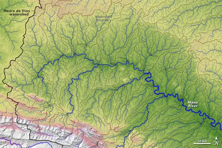
HydroSHEDS (Hydrological data and maps based on SHuttle Elevation Derivatives at multiple Scales) is a global hydrological dataset developed by the World Wildlife Fund (WWF) and the United States Geological Survey (USGS). It provides high-resolution information on river networks, watershed boundaries, and flow direction that can be used for various water management applications. HydroSHEDS data is freely available and widely used by researchers, policymakers, and practitioners in water resources management and environmental studies.
Key Components of the HydroSHEDS Dataset
River Network
HydroSHEDS provides information on the location and connectivity of rivers and streams at different scales. This data can be crucial for understanding the flow of water within a region and identifying the main river channels and their tributaries.
Watershed Boundaries
The dataset delineates watershed boundaries based on topographic information, enabling the identification of catchment areas for specific river segments. This is essential for managing water resources, as it helps in defining the areas that contribute to the flow of water in a given river.
Flow Direction
HydroSHEDS uses digital elevation models (DEMs) to determine the direction of water flow in the landscape. This information is vital for modeling hydrological processes and understanding how water moves through a region.
About HydroSHEDS Data
HydroSHEDS data is typically available in Geographic Information System (GIS) compatible formats like raster and vector data. You can access and download HydroSHEDS data from various sources, including the WWF website and the USGS EarthExplorer platform.
Applications of HydroSHEDS Data in Water Management
Water Resources Assessment
HydroSHEDS data can be used to assess the availability of water resources in a region, such as estimating streamflow, identifying potential water sources, and analyzing water availability over time.
Floodplain Mapping
The dataset can assist in mapping flood-prone areas, which is vital for disaster management and land-use planning.
Water Quality Modeling
HydroSHEDS data, combined with other environmental data, can be utilized to model water quality parameters, aiding in the assessment of pollution and potential impacts on aquatic ecosystems.
Infrastructure Planning
When planning water-related infrastructure, such as dams, reservoirs, or irrigation systems, HydroSHEDS data can provide essential information on the river network and watershed characteristics.
Biodiversity Conservation
Understanding river networks and watersheds is crucial for preserving aquatic biodiversity, as these habitats support a wide range of aquatic species.
HydoSHEDS Disclaimer
It’s important to note that while HydroSHEDS provides valuable information for water management, it may require further validation and integration with local data, especially for site-specific applications.


