Geospatial Data: Understanding, Collection, and Applications

Imagine a world where everything and everywhere could be traced, analyzed, and leveraged for various purposes. Welcome to the age of Geospatial Data!
Introduction
Geospatial data refers to data that is linked to a specific location on the Earth's surface. It encompasses a wide range of data types, including maps, satellite imagery, and GIS (Geographic Information System) data. The use of geospatial data has become increasingly important in recent years due to advancements in technology and the growing need for accurate and up-to-date information about our physical world.
Geospatial data is used in a variety of fields, including navigation and mapping, environmental and resource management, urban planning and development, and emergency response and disaster management. The importance of geospatial data lies in its ability to provide a visual representation of the world and to help decision-makers make informed choices based on accurate, real-world information.
In this article, we will explore the various aspects of geospatial data, including what it is, how it is collected, and its various applications. We will also delve into the different types of geospatial data, their characteristics, and how they are used in various fields. By the end of this article, you will have a comprehensive understanding of geospatial data and its significance in our world today.
Understanding Geospatial Data
Geospatial data forms the bedrock of numerous industries, from environmental science to logistics and beyond. To effectively leverage its capabilities, one must first grasp its different types, characteristics, and the frameworks that allow us to accurately pinpoint locations on the Earth's surface. This section aims to unpack the complexities and nuances of geospatial data to enable better decision-making and more effective application in various fields.
Types of Geospatial Data
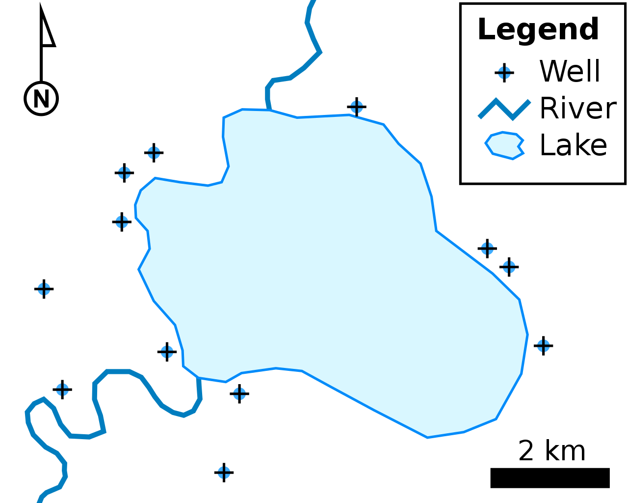
Vector Data
Vector data is primarily made up of points, lines, and polygon shapes. Each of these elements is defined by a coordinate in space.
Points: Represent specific locations like street lamps, mailboxes, or any other object that can be represented by a single x, y coordinate. For example, the location of a particular store in a shopping mall can be depicted as a point.
Lines: Used to illustrate linear features such as roads, rivers, and utility lines. Each line is made up of a series of points connected in a particular sequence.
Polygons: These are closed lines used to represent areas like lakes, building footprints, and city boundaries. Polygons are made up of multiple lines connected end-to-end.
Vector data is often preferred for tasks that require precise measurements and clear delineations, such as cadastral mapping, transportation planning, and network analysis.
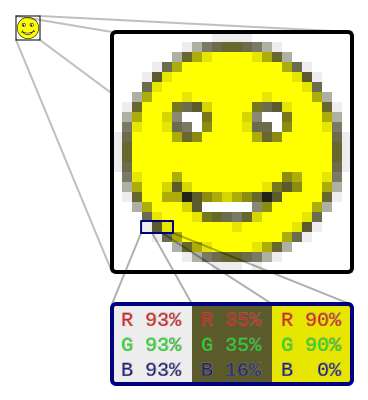
Raster Data
Raster data consists of a matrix of cells or pixels that cover a specific geographical area. Each cell holds a value representing information like elevation, temperature, or vegetation type. This kind of data is particularly useful in applications like satellite imagery, weather mapping, and geological surveys.
Cell-based Representation: The granularity of the data is defined by the size of the cell. Smaller cells mean more detail but result in larger file sizes.
Value Representation: Each cell can hold one or multiple values, offering either a simple representation, like land vs water, or a complex one like the RGB values for color images.
Raster data is beneficial for applications that require continuous data over a specific area, such as land cover mapping or climate modeling.
Characteristics of Geospatial Data
Geographic Location: The most fundamental characteristic, it refers to the actual physical location where the data point exists. It's often expressed in terms of latitude and longitude or other coordinate systems.
Spatial Relationships: This describes how different data points relate to each other in space. It can include proximity, intersection, and inclusion within boundaries. These relationships are essential in applications like route planning, disaster management, and landscape architecture.
Attributes: These are additional data attached to geographic features. For example, a point representing a hospital would include attributes like name, number of beds, or emergency service availability. This added layer of information allows for a richer analysis and more nuanced understanding.
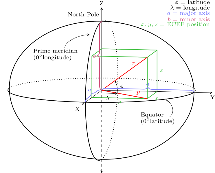
Coordinate Reference Systems (CRS)
Understanding CRS is pivotal for accurately mapping and analyzing data. A Coordinate Reference System provides the rules and frameworks needed to describe locations.
Geographic Coordinate Systems: These are based on a spheroid and use latitude and longitude to define location. They are often used for global datasets and are ideal for preserving angles and areas.
Projected Coordinate Systems: These are 2D systems ideal for representing small areas. Unlike Geographic Coordinate Systems, these use x, y coordinates on a flat plane, making them useful for accurate distance and area calculations for localized projects.
Collection of Geospatial Data: A Deep Dive
The collection of geospatial data is a complex and nuanced process, requiring specialized knowledge, tools, and techniques. Below, we explore some of the primary methods and sources for collecting this indispensable form of data.
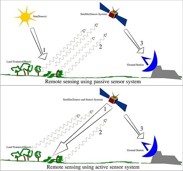
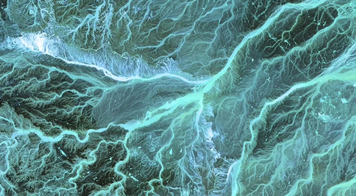
Remote Sensing: Eyes in the Sky
Remote sensing is a revolutionary technique that has vastly expanded our ability to collect geospatial data. Through the use of airborne or satellite-based sensors, vast amounts of data can be gathered without the need for physical presence on the ground. Here are some key types of remote sensing:
Aerial Photography: High-resolution cameras mounted on airplanes capture detailed images of the Earth's surface.
Satellite Imagery: Satellites equipped with sensors orbit Earth and can collect a variety of data including visible light images, infrared data, and even radar imagery.
LIDAR: Stands for Light Detection and Ranging, a remote sensing method that uses light in the form of a pulsed laser to measure distances.
Applications:
- Resource Management
- Environmental Monitoring
- Urban Planning
Surveying: The Ground-Level View
Surveying is the traditional method of geospatial data collection involving on-the-ground measurements and observations. Some key tools include:
GPS (Global Positioning System): This involves using a GPS device that communicates with satellites to determine precise locations on Earth.
Total Station Instruments: These are electronic/optical instruments used in building construction and modern surveying to measure distances and angles.
Tape Measures and Wheels: For less technical needs or for supplementing electronic methods, physical tools like tape measures and measuring wheels can be used.
Applications:
- Land Demarcation
- Infrastructure Development
- Archaeological Excavations
GIS Databases: The Repositories
Geospatial Information System (GIS) databases serve as repositories for storing, maintaining, and managing geospatial data. These databases are maintained by various organizations, including:
Government Agencies: National and regional databases often used for public service applications like urban planning and disaster response.
Private Companies: Used for commercial applications like logistics, market analysis, and real estate.
Non-Profit Organizations: Employ GIS databases for research and activism, such as monitoring environmental change or human rights abuses.
Applications:
- Academic Research
- Policy Analysis
- Commercial Exploitation
Raw Methods of Geospatial Data Collection: Unveiling the Techniques
Field Data Collection: The Human Touch
Field data collection is often the first step in any geospatial project. This method involves direct measurement and observation of features on the ground using tools like GPS devices or total station instruments.
Applications:
- Natural Resource Surveys
- Wildlife Tracking
- Social Science Studies
Aerial Photography: A Bird's Eye View
Aerial photography takes the use of cameras to the skies, typically mounted on airplanes or drones. This method offers a compromise between the broad scope of satellite imagery and the detailed focus of field data collection.
Applications:
- Land Use Planning
- Environmental Studies
- Agricultural Monitoring
Satellite Imagery: The Orbital Perspective
Satellite imagery provides the most comprehensive view of the Earth's surface. Satellites equipped with specialized sensors capture a wide range of data types, from visible spectrum images to thermal and infrared data.
Applications:
- Climate Studies
- Global Surveillance
- Natural Disaster Prediction and Monitoring
The Synergy of Methods
The collection of geospatial data is not an either/or situation. For the most accurate, detailed, and comprehensive data, a combination of these methods and sources is often employed. This multi-pronged approach ensures data reliability and provides a fuller understanding of the complexities of our world.
By using a variety of techniques, from boots-on-the-ground surveying to eyes-in-the-sky remote sensing, we can gather the data needed to make more informed decisions, solve complex problems, and better understand the world we inhabit.
Sources of Geospatial Data
United States Geospatial Data Sources
US National Park Service Geospatial Data Sources
US Environmental Protection Agency Geospatial Data Sources
National Oceanic and Atmospheric Administration Geospatial Data Sources
Applications of Geospatial Data: Unlocking its Multifaceted Utility
Geospatial data is an integral part of a multitude of fields, driving solutions to complex problems and improving decision-making. Below, we delve into some key applications of geospatial data.
GIS: The Core of Spatial Intelligence
Geospatial Information Systems (GIS) stand at the forefront of geospatial data applications. GIS platforms perform multiple roles:
Mapping: The creation of digital maps enables a host of applications from urban planning to ecological conservation.
Spatial Analysis: GIS can analyze spatial relationships between various data layers, helping to model and understand complex systems like climate patterns or traffic congestion.
Decision Support: GIS models can assist policymakers by providing data-driven insights into problems like public health crises or housing shortages.
Real-world Examples:
- Identifying optimal locations for renewable energy farms.
- Modeling the spread of diseases.
- Route optimization in logistics.
Navigation: Guiding the Way
With the ubiquity of smartphones, geospatial data's role in navigation has never been more crucial.
Maps: High-accuracy maps are essential for everything from hiking in national parks to navigating through cities.
Location-Based Services: Apps that provide real-time data, like ride-sharing services or restaurant finders, rely on geospatial data.
Maritime and Aerospace Navigation: High-stakes applications include shipping routes and air traffic control, where accuracy is non-negotiable.
Real-world Examples:
- GPS-based apps for real-time public transport tracking.
- Precision agriculture using location-based analytics.
- Autonomous vehicles' path planning.
Environmental Management: Earth’s Stewardship
Geospatial data plays a pivotal role in managing Earth's resources responsibly.
Resource Monitoring: Detailed geospatial data helps in the careful management of forests, freshwater sources, and mineral reserves.
Impact Assessment: Before any new development, geospatial data helps to model the potential environmental impact.
Wildlife Conservation: Satellite and drone imagery can help track endangered species and understand their habitats.
Real-world Examples:
- Analyzing deforestation rates in the Amazon.
- Mapping coral reefs for conservation efforts.
- Water quality monitoring in lakes and rivers.
Urban Planning and Development: Shaping Liveable Cities
In the context of rapid urbanization, the importance of geospatial data in urban planning cannot be overstated.
Land Use Planning: Geospatial data helps in zoning decisions, optimizing for residential, commercial, and public spaces.
Infrastructure Development: Everything from roads to sewage systems relies on accurate geospatial data.
Smart Cities: Advanced geospatial analytics can lead to more efficient public services, from waste management to public transportation.
Real-world Examples:
- 3D city models for simulating pedestrian movement.
- Mapping underground utilities.
- Optimizing routes for emergency services.
Emergency Response and Disaster Management: Lifesaving Insights
When disaster strikes, quick and effective response can mean the difference between life and death, and geospatial data is invaluable in these situations.
Disaster Prediction: Advanced models can predict the path of hurricanes or the spread of wildfires.
Response Coordination: During events like natural disasters, geospatial data helps in coordinating rescue efforts effectively.
Post-Disaster Assessment: After the immediate crisis, geospatial data can be used to assess damage and plan recovery efforts.
Real-world Examples:
- Identifying flood-prone areas for evacuation.
- Aerial imaging for assessing damage post-earthquake.
- Mapping the spread of wildfires in real-time.
Each of these applications not only stands as a testament to the utility of geospatial data but also underscores the interdisciplinary approach necessary for tackling today's complex challenges. From daily conveniences to crisis management, geospatial data shapes our interaction with the world in profound ways.
Conclusion: The Unseen Engine Driving Modern Progress
In a world that is increasingly data-driven and interconnected, the role of geospatial data as a vital underpinning for multiple sectors cannot be overstated. From influencing everyday decisions through mapping and navigation apps, to tackling the planet's most pressing environmental challenges, geospatial data serves as the backbone of a multitude of applications that enrich our quality of life and ensure a sustainable future.
We've journeyed through the intricacies of GIS, the immediate utility of geospatial data in navigation, its pivotal role in environmental stewardship, its indispensable value in urban planning, and its life-saving potential in emergency and disaster management. Each of these applications not only demonstrates the extensive reach of geospatial data but also encapsulates the necessity for an interdisciplinary approach in leveraging this invaluable resource.
As technology advances, so too will the applications and capabilities of geospatial data. This makes it more important than ever to understand its complexities, capabilities, and potential impacts. It's not just about coordinates and maps; it's about a more resilient, efficient, and interconnected world.
By diving deep into the multifaceted applications of geospatial data, we don't just better understand the world around us—we gain the tools and insights needed to improve it. And in a world facing complex and interwoven challenges, that's not just significant; it's absolutely essential.